{
    "type": "FeatureCollection",
    "features": [
        {
            "type": "Feature",
            "geometry": {
                "type": "LineString",
                "coordinates": [[-70.3173739,43.69597],[-70.317183,43.695966]]
            },
            "properties": {
                "segmentId": "11405940_0",
                "name": "Wendell Street",
                "roadClass": "residential",
                "priorityLevel": "5",
                "reverseId": "-11405940_0"
            }
        },
        ...
    ]
}
Got feedback? Additional questions? Just want to have a friendly chat?
Get in touch!
Available parts
- Goal
- Road data variants (current)
- Data set types for road data
- Further reading
Variants of road data supported
The xyzt.ai platform supports three main variants of road network-defined data:
-
Static Data Defined on Road Segments This is multi-variate data (i.e., multiple attributes per road segment) that does not change over time.
-
Temporally Aggregated Traffic Data This variant includes data that varies over time, such as the average speed driven on each road segment for each 5-minute interval of the day.
-
Trips Defined Along a Road Network This data includes sequences of roads followed by multiple vehicles (often millions), and can include metrics like speed driven.
Accepted formats
The platform is data provider-agnostic and accepts data from providers like TomTom, HERE, INRIX, or your own data. However, it requires the data in a specific format, explained below for the three variants:
Static data defined on road segments
The platform expects data in (gzipped) GeoJSON format or zipped SHP format.
Here is an example of such a data set using the GeoJSON format, consisting of a FeatureCollection where each Feature corresponds to a road segment:
Example static road data file
The data should have at least a unique identifier (segmentId in the example), and ideally additional properties like:
-
name: A human-readable name for labeling. -
priorityLevel: Indicates the importance of the road (1 = most important). -
reverseId: For two-way roads, identifies the opposite direction.
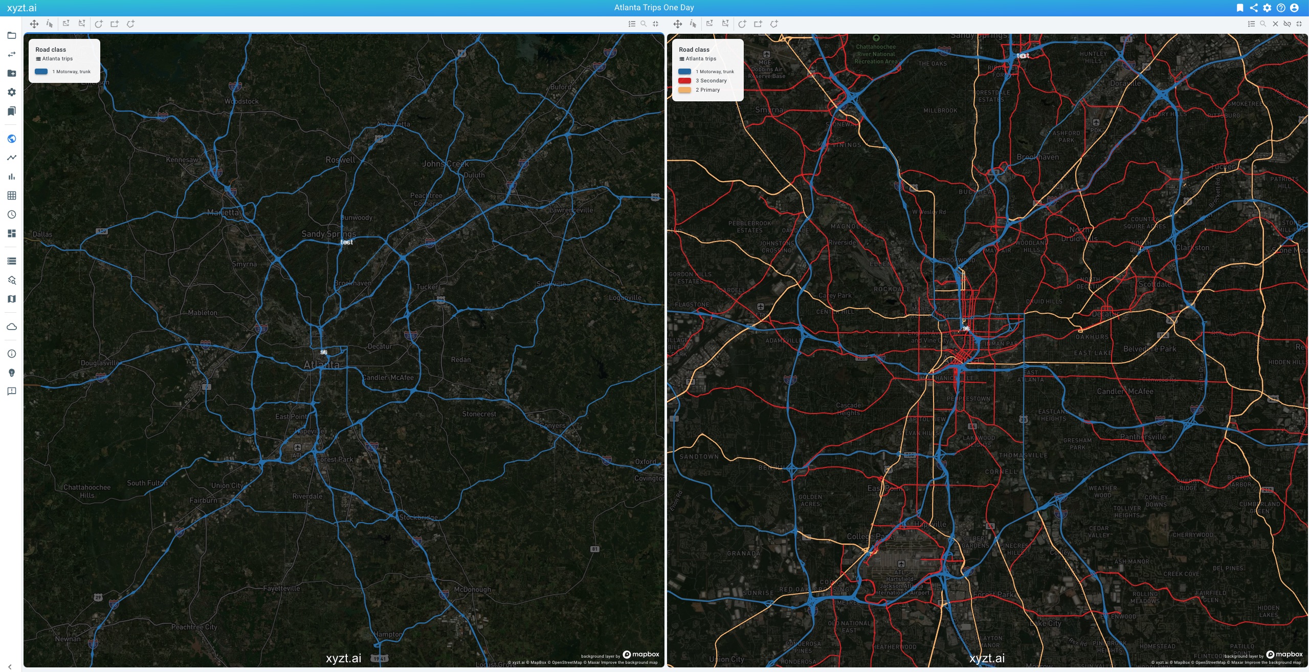
Figure 1. Multi-scale handling of road network data. Left; Only showing the motorways when zoomed out. Right: also showing the smaller roads when zooming in.
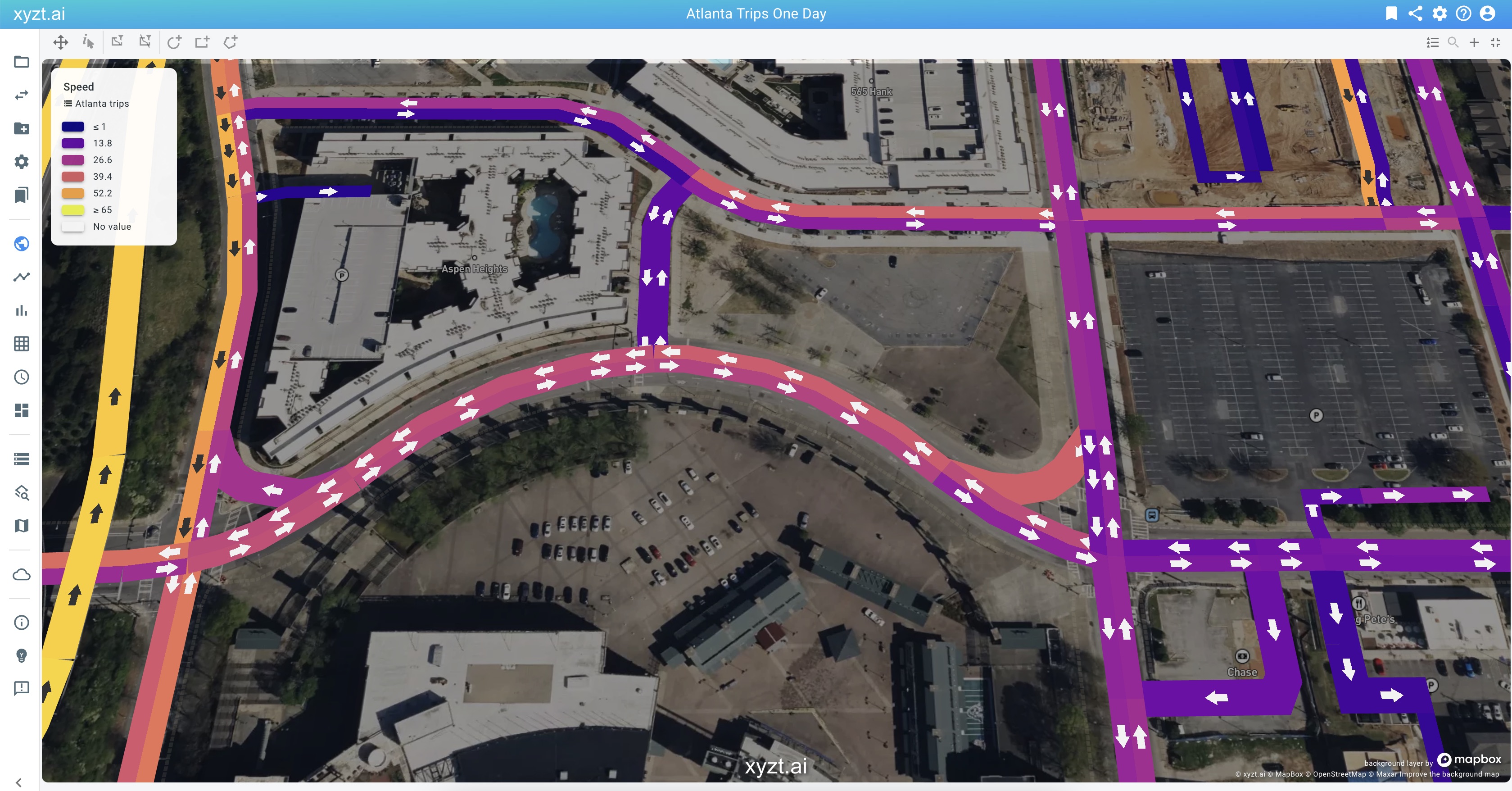
Figure 2. Handling of two-way roads, with indication of driving direction.
You can also use different names for these properties and add others, such as roadClass.
When uploading, you can use gzipped GeoJSON files (.geojson.gz), and each file should be gzipped individually. When working with SHP files, you have to provide one or more shape files as a zip file (.zip). In all cases, you can upload multiple files.
Temporally aggregated traffic data
This type of data, often referred to as traffic stats, includes a temporal dimension and provides data for each road segment over time.
Expected format:
-
One or more (gzipped) GeoJSON or SHP files similar to above.
-
One or more (gzipped) CSV files (
.csvor.csv.gz) or one or more Parquet files (.parquet).
These CSV or Parquet files should include the following columns:
-
A column containing the unique identifier of the road segment. In the example above it should correspond to the
segmentIdvalues. -
A column (property) containing the timestamp.
-
Additional properties with data relevant for your analysis, such as a column containing the Average Speed, or the Number of Trips, or any other attribute.
This is an example of such a file:
Time series traffic stats data defined on above road network.
GeometryId;Timestamp;Average Speed;Number of Trips
1322828250_6;2025-02-10 12:15:00;9.8;112
1322828250_6;2025-02-10 13:40:00;6.2;131
1322828250_6;2025-02-10 05:40:00;10.8;133
1322828250_7;2025-02-10 17:25:00;9.3;14
1322828250_8;2025-02-10 00:35:00;15.0;156
1322828250_9;2025-02-10 05:30:00;13.2;1132
1322828250_0;2025-02-10 06:30:00;7.8;1244
1322828250_0;2025-02-10 12:55:00;11.2;101
1322828250_0;2025-02-10 08:15:00;29.9;12
...Trips defined along a road network
The final variant that the xyzt.ai platform supports is data consisting of trips of vehicles along a road network.
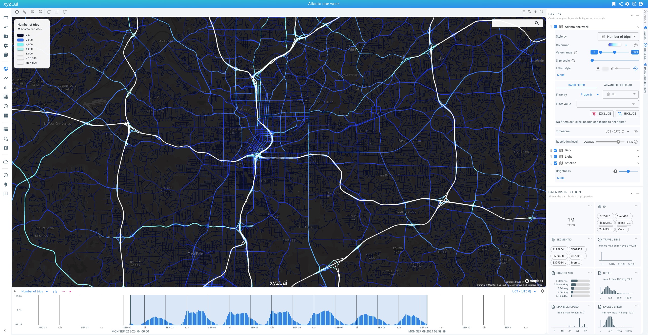
Figure 3. Example movement path data set from INRIX consisting of trips along a road network.
Similar to the static geometry and the timeseries case, the platform requires one or more (gzipped) GeoJSON files or zipped SHP files defining the road network, ideally with the properties as defined above.
In addition, this data variant accepts two types of additional files:
-
(gzipped) CSV (
.csvor.csv.gz) files or Parquet (.parquet) files files containing time-varying trips data, where each row represents a segment of a trip and includes time-dependent values (e.g., Speed). Each trip must have a unique identifier (TripId). These are called data files. -
Optional: (gzipped) CSV (
.csv or `.csv.gz) files or Parquet (.parquet`) files containing constant trip data, with one row per trip defining attributes like VehicleType. These are called metadata files and are linked to the data files via the unique TripId.
You can also store constant trip attributes like Vehicle Type directly in the data records, as shown below:
Example trips data file with embedded metadata (VehicleType).
TripID,Timestamp,Speed,VehicleType,SegmentID
id_0,2025-02-10 07:13:49,25.413329811971263,car,11405940_0
id_0,2025-02-10 07:13:51,39.76697196232885,car,11405940_1
id_0,2025-02-10 07:13:51,23.645093995029796,car,11405940_2
id_0,2025-02-10 07:14:13,43.08301345374769,car,11394244_0
id_1,2025-02-10 07:14:13,35.07116281792062,truck,11394244_1
id_1,2025-02-10 07:14:14,33.58726373939426,truck,11394244_2
id_1,2025-02-10 07:14:17,16.74187927430185,truck,11394244_3
id_1,2025-02-10 07:14:24,39.436278809975285,truck,11394244_4
...
Example data sets
Here are example files for each variant:
| Road Data Variant | Files |
|---|---|
Static data defined on road segments |
|
Temporally aggregated traffic data |
|
Trips defined along a road network |
What to do if your data format differs?
There are many ways in which data is represented, such as embedding temporal data in the GeoJSON file or using different formats like GeoPackage.
GeoJSON and CSV are the most open and common formats and are easy to create and inspect. Parquet is also supported for its compressed, columnar data representation. SHP is supported for the geometries as it is a common GIS format.
If you need help converting your data for use with xyzt.ai, don’t hesitate to contact support.
Benefits for working with different road data variants
The platform offers various capabilities for analyzing each data variant. The table below outlines key capabilities:
| Road Data Variant | Description | Capabilities |
|---|---|---|
Static data defined on road segments |
Multi-variate data that does not vary over time. |
Map-based interactive styling and filtering, including comparison analytics. |
Temporally aggregated traffic data |
Data varies over time, e.g., average speed per 5-minute interval. |
All of the above, and in addition performing density analytics and trend analytics. |
Trips defined along a road network |
Sequence of roads followed by multiple vehicles, including speed driven. |
All of the above, and in addition performing origin-destination analytics, traffic flow analytics (cf. selected link analytics), and much more. |
The trips data variant allows the most powerful analytics, especially for traffic flow analysis.
Next part
Go to the next part: Data set types for road data
Got feedback? Additional questions? Just want to have a friendly chat?
Get in touch!