Got feedback? Additional questions? Just want to have a friendly chat?
Get in touch!
The main concepts in managing your data
The xyzt.ai platform provides you with the tools to analyze your location data. As a first step, before you can start analyzing, you will need to tell the platform about your data.
This article introduces the main concepts used by the platform to manage data.
Data stores, Data sets, background layers and areas of interest
-
Data sets: when you upload your location data to the platform, it will be stored inside a dataset.
You create a new data set for each collection of files with spatio-temporal data. For example, it can be a set of files containing GPS records of vessels, or car trips along a road network.
The data in the data set can be styled, filtered and queried.
See the different types of data sets article for an overview of all the data sets the platform supports.
-
Background layers: provide context to your data and will be shown on the spatial map behind your location data. Currently, we support
.geojsonand (zipped).shpfiles, data from a OGC WMS server, Mapbox layers, and (XYZ) Tiles layers.Example background layers are aerial imagery, road networks, building floor plans, etc.
You cannot interact with background layers.
-
Areas of interest: the analysis tools allow filtering on specific areas. These areas can be defined by drawing them on the map, or by uploading a
.geojsonor (zipped).shpfile as area of interest layer.Examples are anchorage areas near ports, shopping stress, or road crossings.
-
Data stores: just like a data set, a data store is a place to store your location data.
The main two differences with a data set is that a data store is unlimited in size, but can’t be used directly for analysis. If you want to use a data store for analysis, you first have to extract a data set from it.
Projects
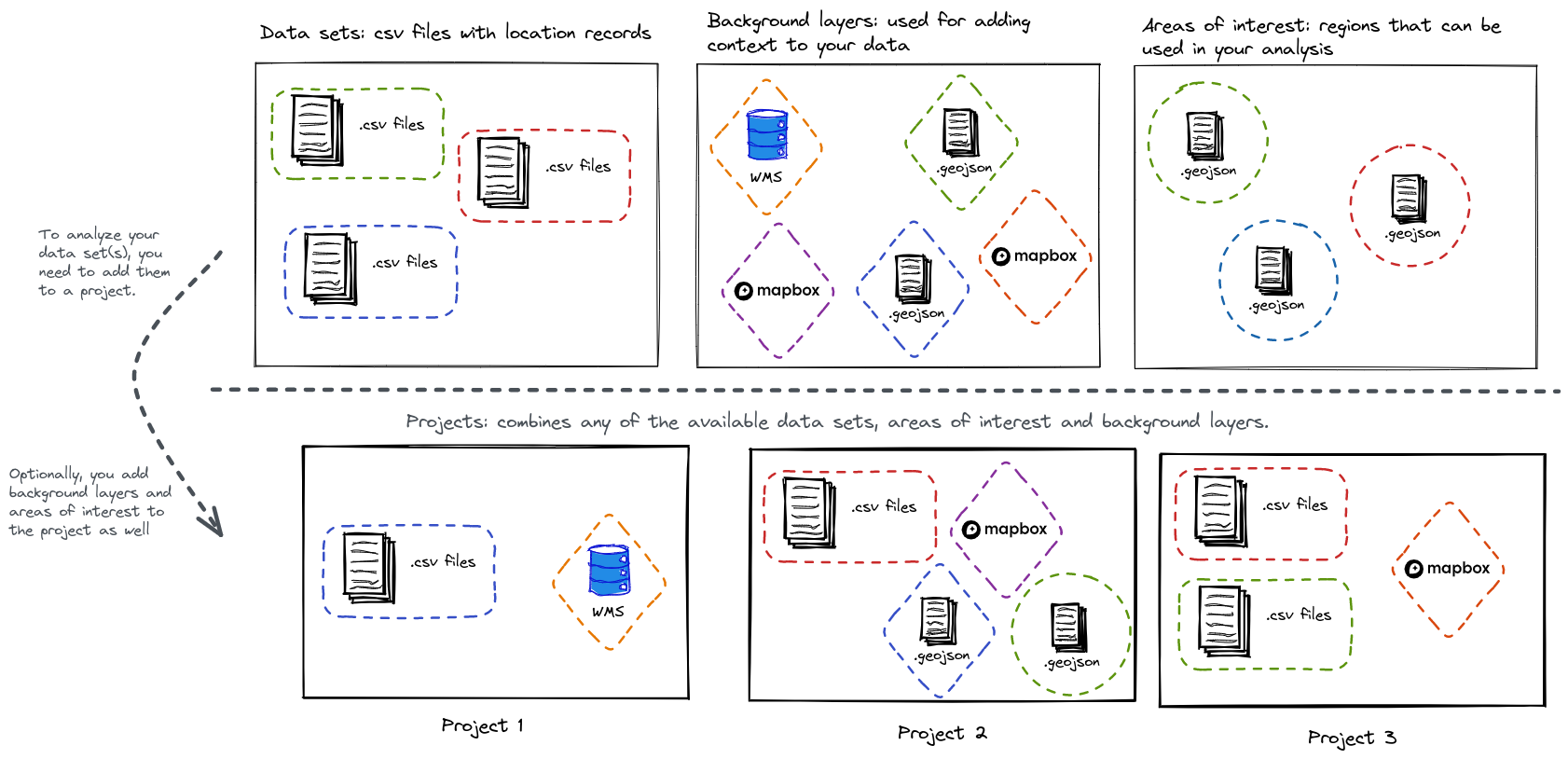
To analyze your location data, you will need to add it to a project. A project combines data sets, areas of interest and background layers and makes them available to the analysis tools.
Figure 1. The relationship between data sets, background layers, areas of interest and projects
|
You can add the same resource to multiple projects
You can add the same data set, background layer or area of interest to multiple projects. You can also add or remove data sets, background layers or areas of interest from/to a project afterwards. |
Different options for GeoJSON/SHP data: background layer, area of interest layer or data set
GeoJSON data (.geojson files) and SHP data (.shp files in .zip archives) can be added as either background layer, area of interest layers, or data sets.
The following table highlights the differences between the three.
| Background layer | Area of interest | Data set | |
|---|---|---|---|
Visible on the spatial map |
✔ |
✔ |
✔ |
Selectable on the spatial map |
❌ |
✔ |
✔ |
Can be used as spatial filter |
❌ |
✔ |
✔ |
Can be used as area to compute statistics |
❌ |
✔ |
✔ |
Static styling, defined in the data |
✔ |
❌ |
❌ |
Dynamic styling, based on the properties in the data |
❌ |
❌ |
✔ |
Dynamic filtering, based on the properties in the data |
❌ |
❌ |
✔ |
Starting an analysis
To start analyzing your data, you need the following steps:
-
Initialize a new data set of one of the different types (
Geometry Data,Timeseries Data,Point Data,Movement Data,Movement Path Data) -
Upload your files into a data set if they aren’t included in an existing data set yet.
-
Optionally, create background layers and areas of interests that you want to use.
-
Create a new project.
-
Include your data set in the project, as well as any background layers or areas of interest you want to use. At this point, your project can be used on the different analytical pages.
-
Navigate to the analysis page you want to use.
For each of those steps, we have articles available with detailed instructions.
Working with data sets
Working with background layers
Working with areas of interest
Working with data stores
Working with projects
Got feedback? Additional questions? Just want to have a friendly chat?
Get in touch!